How to Scout a Property You’ve Never Set Foot On Before the Rut


Justin Hunold
yesterday at 7:18 PM
There’s a certain type of unease that comes with hunting a property you’ve never laid eyes on. You can mask it with confidence, maybe even tell yourself big bucks are where you find them. But deep down, you know the odds are thinner when you’re flying blind. The rut doesn’t wait for you to get your bearings. It hits hard and fast, and if you're not ahead of it, you're behind.
That’s where remote scouting earns its keep.
If you’re using a platform like Infinite Outdoors to book private land access, odds are you might not get the luxury of multiple pre-season trips. But that doesn’t mean you can’t show up with a plan. In fact, the right digital prep can often give you a better blueprint than boots-on-the-ground scouting—as long as you know what to look for.
Here’s how to scout private land remotely and walk into a new property like you’ve hunted it for years.
Start With the Big Picture
Zoom way out. Before you dive into terrain lines and food plots, understand the property’s position in the bigger landscape. The broad perspective is where most hunters go wrong—they look at one property instead of seeing the ecosystem around it. Ask questions like:
- Is it a pinch between two larger chunks of timber?
- Does it border crop fields, public ground, or overlooked bedding?
- What direction do deer likely enter and exit from?
This “macro” view tells you whether deer are using your property or simply passing through. Once you understand that, you can decide whether to hunt aggressively on travel routes or sit back near staging areas.
Integrate the Tech Stack
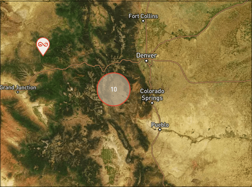
Tools like Google Earth Pro, OnX, and GAIA GPS are still must-haves, but Infinite Outdoors brings a unique advantage here: built-in, onboard mapping features that overlay private parcel boundaries, habitat types, and property-specific access zones. This means you can e-scout directly inside your Infinite Outdoors account—no app-switching, no guesswork.
Use these tools to mark:
- Likely bedding and feeding zones based on cover and crop rotation
- Trail intersections that connect neighboring parcels
- Access points that won’t blow out deer with the prevailing wind
When using Infinite Outdoors mapping, toggle between satellite, terrain, and habitat overlays to see how deer might transition through multiple habitat edges. These visual layers are gold for predicting travel patterns and planning quiet entry routes.
Tap Into Historical Data
If you want to move from “educated guessing” to actual data-backed scouting, use historical weather data to your advantage. Tools like Weather Underground or NOAA Climate Data let you review multi-year trends in wind direction, average temps, and moon phases during previous ruts.
Why it matters:
- Wind patterns help you select stand sites that stay undetected across multiple days.
- Temperature swings often correlate with increased daylight buck activity.
- Moon position can fine-tune your timing for mid-morning movement windows.
Infinite Outdoors hunters can pair this with real-time weather updates in the app to plan arrival and access timing with precision. Combine those insights with aerial mapping, and you can walk into a property already knowing how deer have likely reacted to similar conditions in past seasons.
You’re not just looking for deer. You’re looking for predictability—and technology gives you the playbook.
Read the Terrain Like a Blood Trail
Once you understand the surrounding landscape, it’s time to interpret how deer have to move based on the terrain within the property. This is where topographic maps come in—those subtle squiggly lines are often more important than rubs or trail-cam photos.
What the Terrain Tells You
Contour lines paint a picture of forced movement. In hill country or broken ground, mature bucks use terrain to stay hidden. That’s your intel—because they’ll do it year after year, rut or not.
Key terrain features to mark:
- Saddles: Low points between two ridges. These are natural travel corridors, especially for bucks cruising mid-morning between doe groups.
- Benches: Flat spots on a hillside. Bucks love to bed here for visibility and thermals. Mark them as potential bedding.
- Spurs: Ridge arms or finger ridges. These often guide deer down into or up from cover and feeding zones.
On smaller private tracts, identifying these features ahead of time allows you to set up close—but not too close—to where deer want to be. That’s how you hunt smart, not desperate.
Layer in Digital Terrain Tools
Infinite Outdoors’ mapping features include terrain overlays that highlight elevation changes and slope direction. Use these to double-confirm your topography reads from apps like OnX and GAIA. It’s like having a second set of eyes.
Pro Tip: Turn on 3D terrain mode on Google Earth to visualize how deer might use a bench or side-hill based on elevation, thermals, and prevailing wind.
Also consider thermals. In the morning, cool air sinks, pulling scent downhill. In the evening, warm air rises. Understanding how these natural scent movements interact with elevation is the difference between bumping a buck and watching him stand up 50 yards away.
Zoom In: Funnels, Edges, and Access
Now you’re looking for the micro-movement stuff—the details that put you in bow range, not just the right zone.
Look for:
- Edge habitat where hardwoods meet CRP, crop fields, or wetlands. Bucks patrol these edges during the rut.
- Inside corners of ag fields where deer naturally stage or cut across.
- Creek crossings, old fence lines, and ditch funnels that force movement.
Use aerial imagery from fall months (October/November if available) to spot:
- Beaten-down trails through leaf litter
- Scrapes under licking branches
- Thin canopy lines indicating heavy travel
Mapping Strategy
In the Infinite Outdoors platform, toggle to habitat layer mode to ID thick bedding, open transitions, and potential staging areas. Combine this with weather and wind forecasts to make a stand plan that works for different conditions.
Entry and Exit: Non-Negotiable
You can’t kill what you spook. Once you find the “kill tree,” backtrack your route and chart entry/exit plans using:
- Prevailing wind history
- Thermal pull (morning vs. evening)
- Cover lines or ditches that let you move in undetected
Mark these on your digital map, and walk them if possible upon arrival. Use flagging or removable tape if needed. Smart access is the insurance policy your hunt needs.
Sync Your Plan With Rut Timing
If you’re hunting November 1st, you’re playing a different game than if you’re in a stand on the 14th. Rut timing changes everything. Bucks behave differently in early, peak, and late phases of the rut, and your strategy needs to match.
- Early November: Bucks are checking scrapes, lightly cruising, and sticking to known travel routes. Focus on active scrape lines and staging areas near doe groups. Hunt afternoons where thermal pull won’t betray you.
- Mid-November: This is peak chaos. Bucks are locked in on does, and travel patterns become less predictable. Focus your scouting on known doe bedding areas—thick cover with escape routes. Bucks will be scent-checking the wind edges and downwind sides.
- Late November: Most does have been bred, but some younger or late-cycle does keep bucks moving. Focus on food sources and late-season bedding pockets. Evening hunts become critical again.
Knowing when you’re hunting lets you decide what you should target—and how aggressive to be.
How Much Time Before the Hunt Should You Start Scouting?
Ideally, begin your remote prep 4–6 weeks out. That gives you time to:
- Analyze weather trends
- Compare historical rut patterns
- Track wind history
- Mark potential stand locations based on terrain and habitat
If you wait until the week before, you’re behind. You’ll still learn something, but you’re reacting—not planning.
Is Remote Scouting Enough to Guarantee Success?
No. But it shifts the odds dramatically in your favor.
Remote scouting gives you a strategic direction, but the final puzzle pieces always come from boots on the ground. Digital maps tell you where to look, but only fresh sign, trail cams, and gut instinct confirm where to sit.
The hunters who combine digital prep + physical verification consistently find success. Infinite Outdoors helps you build that advantage faster.
What Tools Do You Need to Scout Effectively?
Here’s a quick loadout of what you need:
- Satellite imagery tools: Google Earth Pro, OnX, GAIA GPS
- Topo mapping apps: Infinite Outdoors map overlay, GAIA’s terrain layer
- Weather + wind apps: Windy, HuntStand, Weather Underground
- Property access info: Infinite Outdoors platform for parcel boundaries and custom entry points
Pro Tip: Infinite Outdoors’ integrated mapping features let you store custom pins, stand locations, and access routes within the same interface you used to book the property.
How to Refine With On-the-Ground Intel
Once you arrive, your digital map becomes your battle plan. You don’t have to wander. You don’t have to second-guess.
Instead:
- Walk the routes you mapped for entry/exit
- Confirm scrapes, trails, or rubs near predicted funnels
- Check trails for freshness—tracks, droppings, browse pressure
- Hang cams in high-traffic pinch points
Let the terrain and sign confirm (or adjust) your digital predictions. Often, you’ll find that bucks are doing exactly what your prep told you they would—you just need to tweak the details.
Glassing from a distance on morning one can also fine-tune your assumptions without polluting the ground.
Does This Work for Public Land Too?
Yes. Everything outlined here applies to public ground as well, especially if you’re bouncing into a new unit or trying to hunt pressure-smart deer.
That said, the advantage of Infinite Outdoors is the ability to scout and access private ground that isn’t overrun. It’s not “easier,” but it reduces the wildcards—giving you a more predictable chessboard to hunt on.
Final Thought
Scouting private land remotely isn’t just a hack. It’s a necessity in the digital hunting age. And when done right, it stacks the odds in your favor before you ever unzip a gear bag.
Just don’t mistake screen time for stand time. Let the e-scouting guide you, but remember—the hunt doesn’t start until the wind hits your face.